


")


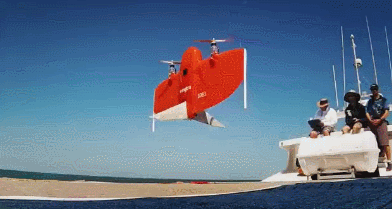
Meet the WingtraOne: an advanced mapping drone for large scale surveys that can get the job done a whole lot faster. It can fly at 16 m/s for 59 minutes and uses a 42MP camera to capture more detail. Thanks to its VTOL design, WingtraOne can take-off and land almost anywhere and can collect data in areas other drones can’t.
VTOL drone WingtraOne

WingtraOne data-based fire damage assessment of CZU lightening complex

This drone comes with a rugged tablet and flight planning app. It can be used with offline maps. The above videos show it in action.
[HT]
**Disclaimer: Our posts may feature aff links. As an Amazon Associate, we earn from qualifying purchases. Please read our disclaimer on how we fund this site.


